Introduction
The Community Earth System Model (CESM) is a global Earth system modelling framework developed by a consortium several universtities and research institutes and lead by the National Center for Atmospheric Research (NCAR). CESM has a long development record starting with the first global coupled climate models in the 1980s and 1990s, followed up by the development of the Community Climate System Model (CCSM) in the 2000s, and ending with CESM version 1 (CESM1) in 2013, and the latest version of CESM, CESM version 2 (CESM2), which was released in 2018.
At IMAU, researchers work with both CESM1 and CESM2.
Model setup
CESM consists of separate model components (representing atmosphere, ocean, land, sea ice, land ice, river runoff, and surface waves) that exchange states and fluxes via a central coupler. The model components can be run in partially or fully coupled mode. Once CESM is applied in a partially coupled mode, the model components that are not active are applied as stub or external data components.
At IMAU, researchers work with both CESM1 and CESM2.
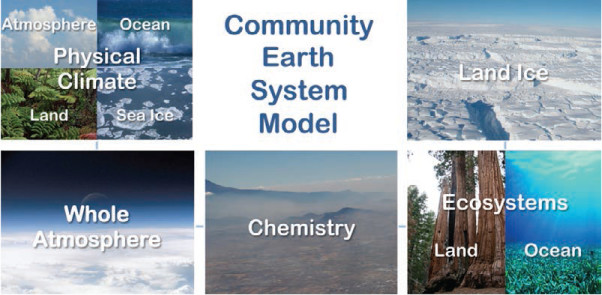
Figure from Hurrel et al. (2013).
CESM1
In CESM1, the atmosphere component of CESM can be represented by the Community Atmosphere Model version 5 (CAM5) for low-top atmosphere (~40 km, 32 vertical levels by default), the Whole Atmosphere Community Climate Model (WACCM) for high-top atmosphere (~130 km, 70 vertical levels by default), or CAM-CHEM that represents the implementation of atmospheric chemistry in CESM. The ocean component is represented by the Parallel Open Program (POP) of the Los Alamos National Laboratory (LANL), which uses 60 vertical levels by default with thicknesses varying from 10 m at the surface to 250 m at depth. The Community Ice Code version 4 (CICE4), the representative of sea ice in CESM1, has also been developed by LANL. On the land, the Community Land Model version 4 (CLM4), the River Transport Model (RTM), and the Glimmer-Community Ice Sheet Model (Glimmer-CISM) are the representatives of the land surface, river runoff, and land ice in CESM, respectively. The different model components are coupled with each other via the CESM coupler version 7 (CPL7). More information about CESM1 can be found on the website of NCAR or in Hurrell et al. (2013).
CESM2
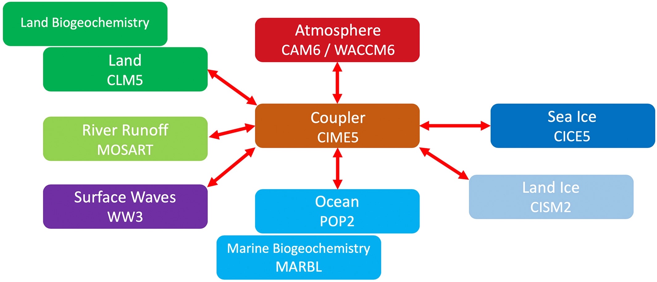
CESM2 is the updated version of CESM, which includes many substantial modifications and improvements in the science and infrastructure of CESM. CAM6 and WACCM6 include, for instance, new parametrization schemes, such as the Cloud Layers Unified by Binormals (CLUBB) scheme, which is a combined shallow convection, turbulence, and cloud macrophysics scheme. POP2 includes several improved parameterizations as well, for instance on the freshwater exchange in estuaries. Also, to better represent waves at the ocean surface, a new model component has been incorporated into CESM, which is the NOAA WaveWatch III ocean surface wave prediction model (WW3). Further CICE4 is upgraded to CICE5, which includes enhanced vertical levels for sea ice, amongst others. CLM5 includes new and updated parameterizations on for instance snow density, snow compaction, and firn formation. Further the one-way coupled Glimmer-CISM is replaced by the two-way coupled CISM2 to better represent the evolution of the Greenland Ice Sheet, and the RTM is replaced by the Model for Scale Adaptive River Transport (MOSART), which treats river runoff in a different way. Finally, the different model components are embedded in a new modelling framework, also called the Common Infrastructure for Modelling the Earth (CIME). More information about CESM2 can be found on the website of NCAR or in Danabasoglu et al. (2020).
The figure shows an overview of the CESM2 model components (Danabasoglu et al., 2020)
Model Grids
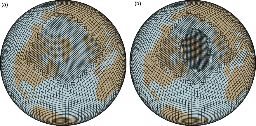
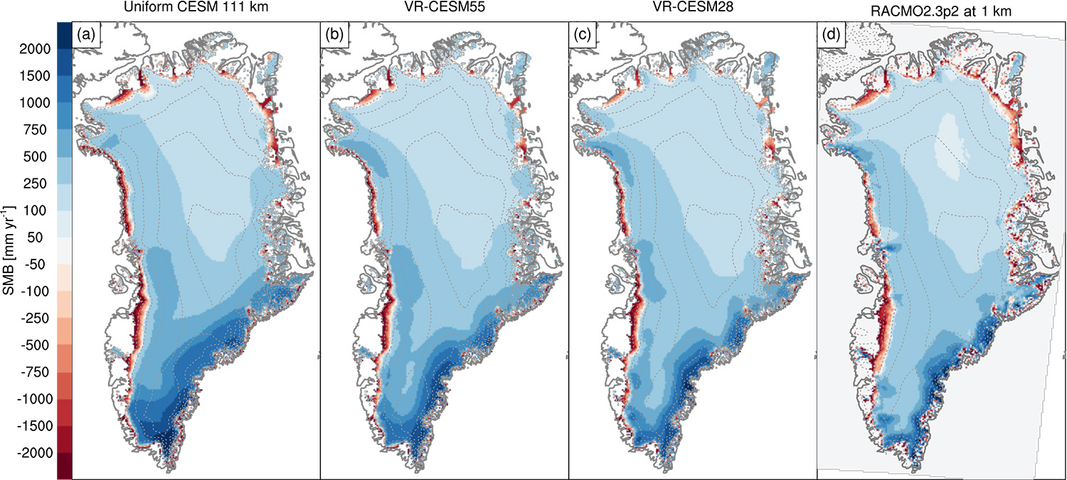
CESM can be applied by using different supported model grids, which include 1) finite volume (FV) grids, and unstructured spectral element (SE) grids. At IMAU, simulations are or have been performed with uniform 1 degree and 0.25-degree FV grids as well as uniform 1 degree and 0.25-degree SE grids. SE grids are also used for Variable Resolution CESM (VR-CESM) applications. VR-CESM simulations use VR grids that are characterized by a regional grid refinement over a region of interest (e.g., a regional grid refinement of 0.25-degrees over the polar regions embedded in a globally 1-degree SE grid).
The figure shows VR grids with regional refinements of 0.5 degrees (a) and 0.25 degrees (b) over the Arctic/Greenland (van Kampenhout et al. 2019)