This document should describe the input data for TM5, and how it is created.
A TM5 meteo file is named following the naming convention for ECMWF files (section 2.2.2):
<class>/<type>/<year>/<month>/<levtype>[<nlev>]/<grid>/<param>_<date>[<fckey>]_<times>.gbExample:
od/fc/2002/10/ml60/glb3x2/uvsp_20021018_21p06.hdf
Overview of the keys in the filename:
Idea is that 'day' specifies the day for which the data is valid, and the postfix distinquishes between different forecasts valid for that day. No postfix simply means 'the best available data'; this could be 4d var data but also a forecast over a few hours.
A simple convention to have a file name containing a complete description of the contents is to replace all '/' in the full path with '-' :
od-4v-2002-06-ml60-glb3x2-uvsp_20020618_03p03.gbTo achieve this in csh, use for example the sed command:
set fullpath = od/4v/2002/06/ml60/glb3x2/uvsp_20020618_03p03.gband for the reverse:
set longname = `echo $fullpath | sed -e's^/^-^g'`
set longname = od-4v-2002-06-ml60-glb3x2-uvsp_20020618_03p03.gb
set fullpath = `echo $longname | sed -e's^-^/^g'`
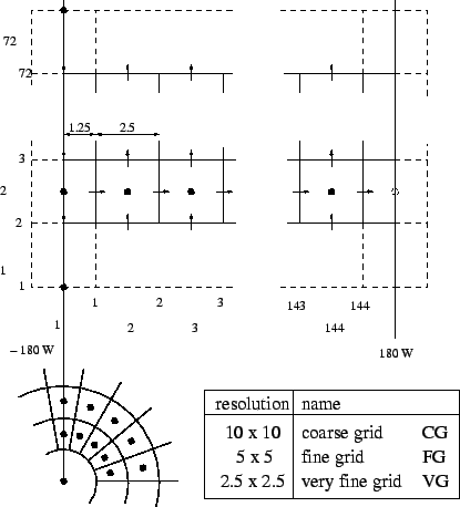
Different sets of TM meteo are identified by the 'grid name'. The grid name occures in the directory and file names used to store the meteo.
Examples of grid names are 'glb3x2', 'gl6x4', 'sur1x1'. There is no real convention, but a few characters followed by the lon/lat resolution in degrees is suitable.
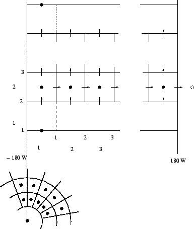
TM5 uses a regular lat/lon grid with different resolutions.
TM3 used to be centered over the date line; in the new version, the dateline is the western border.
| TM5 grid position | TM3 grid position |
|---|---|
 |
 |
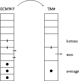
TM5 levels are always formed following the ECMWF levels. Optionally, some levels are combined into a single level.
The level ranges are defined in two source files:
Currently implemented TM levels are:
| nlev | used by | description |
|---|---|---|
| 60 | parent data set | All ECMWF levels |
| 44 | TM3dam (Henk, Arjo) | low resolution in troposphere |
| 33 | TM-SCIA (Michiel, Ernst), TM5 (Bram) | double layers (close to original ECMWF 31 layers) |
| 25 | TM5 (Maarten) | |
| 1 | general purpose | surface fields |
With the files for one day the TM models can be run from 21h on the former day until 21h of the day itself.
Fields are stored in the files with the following description: